Showing posts with label commuting. Show all posts

Friday, December 8, 2017

Commuting, Median Rents and Language Other Than English

New American Community Survey Statistics Provide Local Data for Every Community Nationwide

English
DEC. 7, 2017 — The nation experienced an increase in commuting times and median gross rent along with a rise in English proficiency among those who spoke another language. These are only a few of the statistics released today from the U.S. Census Bureau’s 2012-2016 American Community Survey five-year estimates, which features more than 40 social, economic, housing and demographic topics, including homeowner rates and costs, health insurance and educational attainment.
“The American Community Survey allows us to track incremental changes across our nation on how people live and work, year-to-year,” said David Waddington, chief of the Social, Economic, and Housing Statistics Division. “It’s our country’s only source of small area estimates for socio-economic and demographic characteristics. These estimates help people, businesses and governments throughout the country better understand the needs of their populations, the markets in which they operate and the challenges and opportunities they face.”
The survey produces statistics for all of the nation’s 3,142 counties. In addition, it is the only full dataset available for three-fourths of all counties with populations too small to produce a complete set of single-year statistics (2,322 counties). Each year, Census Bureau data helps determine how more than $675 billion of federal funding are spent on infrastructure and services, from highways to schools to hospitals.
Data Highlights
The following highlights are from the 2012-2016 American Community Survey five-year estimates release, unless otherwise noted.
Commuting Characteristics
Between 2012 and 2016, the average commute time for the nation was 26.1 minutes, an increase of 0.7 minutes from 25.4 minutes in the 2007-2011 American Community Survey five-year estimates data.
·       The longest average one-way travel times are generally associated with larger metro areas or smaller metro areas within commuting distance of a larger metro area. Among the longest were:
o   East Stroudsburg, Pa., metropolitan area (38.6 minutes).
o   New York-Newark-Jersey City, N.Y.-N.J.-Pa., metropolitan area (35.9 minutes).
o   Washington-Arlington-Alexandria, D.C-Va.-Md.-W.V., metropolitan area (34.4 minutes).
·       The shortest average one-way travel times are usually associated with smaller metro areas. Among the shortest were:
o   Walla Walla, Wash., metropolitan area (15.4 minutes).
o   Grand Forks, N.D.-Minn., metropolitan area (15.5 minutes).
o   Great Falls, Mont., metropolitan area (15.6 minutes).
The travel times for Walla Walla, Grand Forks and Great Falls metro areas are not statistically different from each other.
·       About 7.5 million workers (5.1 percent) commute by bus, subway, commuter rail, light rail or some other form of public transportation on a typical workday. Public transportation usage is highly concentrated within the nation’s large metro areas.
·       Among metro areas with high rates of public transportation commuting:
o    The New York-Northern New Jersey-Long Island, N.Y.-N.J.-Pa., metropolitan area stands out with 31.0 percent of workers (2,918,906 people) commuting by transit.
o    The San Francisco-Oakland-Hayward, Calif., metropolitan area and the Washington-Arlington-Alexandria, D.C.-Va.-Md.-W.V., metropolitan area are at 16.5 percent (369,759 people) and 14.0 percent (443,870 people), respectively.
·       County-level commuting data are available here.
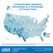
Language Spoken at Home and English-Speaking Ability
Between 2012 and 2016, 21.1 percent (63,172,059) of the population age 5 and older spoke a language other than English at home, an increase from 20.3 percent in the 2007-2011 American Community Survey five-year estimates data.
·       Of those who spoke a language other than English at home, 59.7 percent (37,731,103) also spoke English “very well.” This proportion increased from 57.1 percent in 2007-2011.
·       New data for five languages are available on American Fact Finder Table B16001: Haitian, Punjabi, Bengali, Telugu and Tamil.
o   There were 806,254 people ages 5 and older who spoke Haitian at home. Almost half (48.8 percent) lived in Florida.
o   Of the 280,867 people ages 5 and older who spoke Punjabi at home, 48.0 percent lived in California.
o   Of the 259,204 people ages 5 and older who spoke Bengali at home, 38.6 percent lived in New York.
o   The 321,695 people ages 5 and older who spoke Telugu at home and the 238,699 people speaking Tamil at home were more evenly distributed across many parts of the nation. For both languages, the highest concentration of speakers lived in California, followed by Texas and New Jersey (the number of persons who spoke Tamil in Texas and New Jersey are not statistically different).
Median Gross Rent
The United States experienced a $21 increase in median gross rent — from $928 in 2007-2011 (adjusted for inflation), to $949 in 2012-2016.
·       The 50 most populous metropolitan areas had increases in median gross rent that outnumbered decreases four to one. There were 32 increases, eight decreases and nine that had no change from 2007-2011 data. (Comparisons for the Los Angeles-Long Beach-Anaheim, Calif., metropolitan area cannot be made due to boundary changes.)
·       Of the 551 micropolitan areas, 146 changed, increases outnumbering decreases two to one with 107 increases and 39 decreases.
County-level gross rent data are available here.
Income
·       Of the 3,142 counties in the United States, 563 counties (17.9 percent) experienced a decline in median household income, while median household income increased in 234 counties (7.4 percent).
·       Among the more than 29,000 places in the United States, 3,254 places (11.1 percent) experienced a decline in median household income, while 926 places (3.2 percent) experienced income growth.
·       For the period of 2012 to 2016, the locations with the highest and lowest median household incomes were:
o   By county and county equivalent:
·        Loudon County, Va., Falls Church City, Va., Fairfax County, Va., Howard County, Md., and Arlington County, Va., were among the highest.
·        McCreary County, Ky., Sumter County, Ala., Holmes County, Miss., Stewart County, Ga., and Lee County, Ky., were among the lowest.
o    By metropolitan statistical area:
·        San Jose-Sunnyvale-Santa Clara, Calif., Washington-Arlington-Alexandria, D.C.-Va.-Md.-W.V., California-Lexington Park, Md., Bridgeport-Stamford-Norwalk, Conn., and San Francisco-Oakland-Hayward, Calif., metropolitan statistical areas were among the highest.
·        Brownsville-Harlingen, Texas, Sebring, Fla., McAllen-Edinburg-Mission, Texas, Pine Bluff, Ark., and Valdosta, Ga., metropolitan statistical areas were among the lowest.
o    By micropolitan statistical area:
·        Los Alamos, N.M., Summit Park, Utah, Williston, N.D., Juneau, Alaska, and Gillette, Wyo., micropolitan statistical areas were among the highest.
·        Middlesborough, Ky., Rio Grande City, Texas, Helena-West Helena, Ark., Las Vegas, N.M., and Indianola, Miss., micropolitan statistical areas were among the lowest.
Poverty
·       Of the 3,142 counties across the nation, 167 counties (5.3 percent) experienced a decline in poverty rates, while 566 counties (18.0 percent) showed a rate increase.
·       Looking at the more than 29,000 places in the United States, 1,391 places (4.7 percent) experienced a decline in poverty rates, while 2,927 places (10.0 percent) had their poverty rates increase.
·       From 2012 to 2016, among geographic areas with 10,000 people or more:
o   By county and county equivalent:
·        Falls Church City, Va., and Lincoln County, S.D., had among the lowest poverty rates for counties and county equivalents.
·        Oglala Lakota County and Todd County in South Dakota, Holmes County, Miss., and McCreary County, Ky., had among the highest poverty rates.
o   By metropolitan statistical area:
·        Among all metropolitan areas, Fairbanks, Alaska, California-Lexington Park, Md., Midland, Texas, and Barnstable Town, Mass., had among the lowest poverty rates.
·        Brownsville-Harlingen, McAllen-Edinburg-Mission and Laredo, Texas, had among the highest poverty rates.
o   By micropolitan areas:
·        Los Alamos, N.M., McPherson, Kan., and Dickinson, N.D., were among those with lower poverty rates.
·        aGallup, N.M., Cleveland, Miss., and Rio Grande City and Raymondville, Texas, were among those with higher poverty rates.
Also Released from the American Community Survey:
·       The five-year estimates feature “Comparison Profile” tables. These tables compare differences between the latest set of American Community Survey five-year estimates (2012-2016) and the most recent, nonoverlapping five-year estimates (2007-2011). The tables note statistically significant differences.
·       The Application Programming Interface updated with 2012-2016 American Community Survey five-year estimates statistics.
·       Guidance on making comparisons is available on our website.
New Data Exploration Platform with County-Level Geography Profiles
The U.S. Census Bureau is currently working to streamline online data dissemination to be more customer-driven and user-friendly by creating one centralized and standardized platform to underlie the search on census.govIn addition to being available through the American FactFinder, some of the 2012-2016 American Community Survey five-year estimates will be released through the new platform, which is currently a preview site at data.census.gov. Specific products available include detailed tables, data profiles, subject tables and comparison profiles.
New for this release, data.census.gov is featuring county-level geography profiles, which provide data users a high-level overview of each of the 3,144 counties in a visual format with maps, charts and graphs. These profiles include 2012-2016 American Community Survey five-year estimates data on a variety of topics including income, commuting, home ownership and veterans, as well as business and industry data from the 2012 Economic Census, 2012 County Business Patterns and 2015 Survey of Business Owners.
We encourage you to take a look at data.census.gov and provide your thoughts on our work in progress at cedsci.feedback@census.gov. 
About the American Community Survey
The American Community Survey is the only source of small area statistics for social, economic, housing and demographic characteristics. It gives communities the current information they need to plan investments and services. Retailers, homebuilders, police departments, and town and city planners are among the many private- and public-sector decision-makers who count on these annual results. Visit the Stats in Action Videos page to see examples. These statistics would not be possible without the participation of the randomly selected households in the survey.
Because it is a survey based on a sample of the population rather than the entire population, the American Community Survey produces estimates. To aid data users, the Census Bureau calculates and publishes a margin of error for every estimate. For guidance on making comparisons, please visit census.gov.
Citation Guidance
When sourcing this data, please use “2012-2016 American Community Survey 5-year estimates.”

Friday, August 21, 2015

Census Bureau Releases Commuting Report

The U.S. Census Bureau released a report, Who Drives to Work? Commuting by Automobile in the United States, 2013, which looks at commuting by private vehicle. The report highlights differences in rates of automobile commuting by population characteristics such as age, race, ethnicity, place of birth and the types of communities in which workers live, based on data collected during the 2013 American Community Survey.
Also released is a county-to-county commuting flows table package that looks at traveling to work between counties and the primary travel mode people use, based on American Community Survey data collected from 2006 to 2013.
Highlights from the Report
  • About 86 percent of U.S. workers commuted to work by automobile in 2013; three out of four commuters drove alone.

Wednesday, March 27, 2013

Commuting (Journey to Work) stats

Commuting (Journey to Work) refers to a worker’s travel from home to work. Place of work refers to the geographic location of the worker’s job. Work at home refers to a worker who does not commute to a different geographic area from work, meaning their place of work is their home. Daytime population refers to the estimated number of people who are residing and working in an area during the “daytime” working hours.

There are several surveys conducted by the Census Bureau that ask questions related to commuting including means of transportation, time of departure, mean travel time to work, vehicles available, distance traveled, and expenses associated with commuting.

Monday, March 4, 2013

Megacommuters: 600K in U.S. Travel 90 Minutes, 50 Miles to Work; 10.8 Million Travel an Hour Each Way

About 8.1 percent of U.S. workers have commutes of 60 minutes or longer, 4.3 percent work from home, and nearly 600,000 full-time workers had “megacommutes” of at least 90 minutes and 50 miles. The average one-way daily commute for workers across the country is 25.5 minutes, and one in four commuters leave their county to work.

These figures come from the U.S. Census Bureau’s annual American Community Survey, which provides local statistics on a variety of topics for even the smallest communities.

According to Out-of-State and Long Commutes: 2011, 23.0 percent of workers with long commutes (60 minutes or more) use public transit, compared with 5.3 percent for all workers. Only 61.1 percent of workers with long commutes drove to work alone, compared with 79.9 percent for all workers who worked outside the home.

“The average travel time for workers who commute by public transportation is higher than that of workers who use other modes. For some workers, using transit is a necessity, but others simply choose a longer travel time over sitting in traffic,” said Brian McKenzie, a Census Bureau statistician and author of the brief.

Rail travel accounted for 11.8 percent of workers with long commutes, and other forms of public transportation accounted for 11.2 percent.

Workers who live in New York state show the highest rate of long commutes at 16.2 percent, followed by Maryland and New Jersey at 14.8 percent and 14.6 percent, respectively. The estimates for Maryland and New Jersey are not statistically different from each other. These states and several others with high rates of long commutes contain or are adjacent to large metropolitan areas.

Based on the 2006-2010 American Community Survey, 586,805 full-time workers are mega commuters — one in 122 of full-time workers. Mega commuters were more likely to be male, older, married, make a higher salary, and have a spouse who does not work. Of the total mega commutes, 75.4 percent were male and 24.6 percent women. Mega commuters were also more likely to depart for work before 6 a.m. Metro areas with large populations tend to attract large flows of mega commuters, according to Mega Commuting in the U.S.

Commuting Across County Lines

More than a fourth of all U.S. workers commute outside the county where they live, according to County-to-County Commuting Flows: 2006-2010, a report on commutes between counties. About 27.4 percent of all U.S. workers traveled outside the county where they live for work during a typical week, compared with 26.7 percent in 2000.

[See the Commuting Flows in Your County]

Small counties and county equivalents dominate the list of counties with the highest percentage of workers commuting outside the county where they live. Several of these counties are in Virginia or Georgia within close proximity to metro areas such as Washington, D.C., and Atlanta: including Manassas Park, Va. (91.2 percent), Echols County, Ga. (85.3 percent), Storey County, Ga. (84.6 percent), Camden County, N.C. (83.2 percent), Long County, Ga. (82.1 percent), Carroll County, Miss. (81.8 percent), and Falls Church, Va. (81.8 percent). Because of the margins of error, these percentages are not statistically different from several of the others.

Three counties in the New York City metropolitan area had the highest number of commuters leaving the county where they live for another county. They include workers living in Kings County (Brooklyn), Queens County (Queens) and Bronx County (The Bronx) traveling to New York County (Manhattan) for work.

Workers commuting from Los Angeles County to Orange County, and from Orange County to Los Angeles County in California represented the fourth and fifth largest flows of commuters across county lines, followed by three combinations in the Houston or Dallas metro areas in Texas.

Out-of-State Commutes

The Census Bureau also examined workers who commute across state lines.

In five states and the District of Columbia, one in 10 workers lived in a different state, according to the Out-of-State and Long Commutes: 2011 brief. Among these are several small Eastern states, including Delaware (14.8 percent), Rhode Island (12.8 percent), New Hampshire (10.8 percent) and West Virginia (10.0 percent). North Dakota also showed a high rate of workers who live in a different state at 11.6 percent. The percentages for New Hampshire and North Dakota are not statistically different from each other.

Among all workers in the District of Columbia, 72.4 percent live in a different state. Workers from just two states, Maryland and Virginia, accounted for 70.4 percent who work in the District of Columbia.

“The District of Columbia is a job center for all of its adjoining counties in Maryland and Virginia,” McKenzie said. “No other state’s workforce exceeded 20.0 percent in its rate of out-of-state commuters.”

New Hampshire (17.0), Delaware (16.4), Rhode Island (15.6), New Jersey (14.0) and West Virginia (12.1) also had high percentages of residents leaving the state for work. The percentage for Delaware is not statistically different from the percentages of New Hampshire and Rode Island.

The District of Columbia also had the highest rate of residents traveling across state lines to work at 25.2 percent, followed by Maryland at 18.3 percent. About 12.0 percent of Maryland workers commute to the District of Columbia, and about 13.0 percent of workers living in the nation’s capital commute to Maryland.

The Census Bureau is also releasing an infographic that provides a statistical snapshot about home-based workers in the United States. This infographic presents recent historical trends as well as economic and social characteristics of people working from home at least one day per week. The infographic looks at statistics from the Survey of Income and Program Participation and the American Community Survey. Learn more about home-based workers.

Friday, September 23, 2011

Census Bureau Releases 2010 ACS Single Year Estimates

Topics Include Commuting, Education, Income, Health Insurance and More

The U.S. Census Bureau released findings from the 2010 American Community Survey (ACS), the most relied-on source for up-to-date socioeconomic information every year. The release covers more than 40 topics, such as educational attainment, income, health insurance coverage, occupation, language spoken at home, nativity, ancestry and selected monthly homeowner costs.

The estimates are available in detailed tables for the nation, all 50 states, the District of Columbia, Puerto Rico, every congressional district, every metropolitan area, and all counties and places with populations of 65,000 or more. See the Census Bureau’s American FactFinder database to find statistics for your area. Selected high-level highlights can be found here [PDF].
One illustration of the extent of information available on one
of the major topics covered is the commute to work. According to the data, average travel time for workers 16 and older inched up from 25.1 minutes in 2009 to 25.3 minutes in 2010. The percentage who drove to work alone increased from 76.1 percent in 2009 to 76.6 percent in 2010. Conversely, the percentage who carpooled declined from 10.0 percent to 9.7 percent and the percentage taking public transportation slipped from 5.0 percent to 4.9 percent. Another 4.3 percent worked at home and 2.8 percent walked to work. About 1.7 percent commuted to work in other ways, including commuting by bicycle (731,286), motorcycle (266,777) and taxicab (151,247).
Average travel time to work was highest in Maryland (31.8 minutes), followed by New York (31.3 minutes). North Dakota and South Dakota had the shortest travel times, at 16.1 minutes and 16.8 minutes, respectively. Not coincidentally, Maryland also had the second-highest percentage of workers with jobs outside their county of residence (47.0 percent), behind only Virginia (51.3 percent). New Jersey (45.7 percent) and Georgia (41.6 percent) followed Maryland.

Detailed Report on Commuting

Also released was Commuting in the United States: 2009[PDF], a report that provides additional layers of analysis about commuting patterns for the nation and metro areas. Based on the 2009 ACS, the analysis gives a historical perspective of the nation’s commuting patterns. It also looks at how our commutes differ based on how we get to work, when we leave for work and how long it takes us. It further analyzes commutes based on a host of demographic characteristics, including race and Hispanic origin, occupation, gender, place of birth and other variables.
According to the report:
The recent rise in mean travel time to work is nothing new. In 1980, the first time the Census collected such information, average travel time was just under 22 minutes, then increased to about 25 minutes in 2000, where it remained in 2009.
In 2009, workers who carpooled took longer to get to work than those who drove alone; the difference was largest for those who departed in the midnight to 4:59 a.m. period, where average travel time for carpool commuters was 45.1 minutes, compared with 30.8 minutes for workers who drove alone.
Those who worked in production, transportation and material moving occupations were more likely to depart for work between midnight and 4:59 a.m. than any other occupational category (10.5 percent). At 1.9 percent, those in managerial, professional and related occupations had the lowest percentage of departures during this time period.
Mean travel time to work varied by nativity status: 28.1 minutes for foreign-born workers compared with 24.9 minutes for those who were native-born. Hispanic workers had the longest mean travel time when carpooling (29.0 minutes) and the shortest time for public transportation usage (46.0 minutes).
American Community Survey Brief Series
In addition, the Census Bureau released today a set of four separate briefs based on the 2010 ACS. These short reports supplement detailed tables with additional analysis on four key topics. These include:
Health insurance coverage
Employment ratios
Household income
Foreign-born from Latin America and the Caribbean
More than a dozen additional briefs will be released in monthly waves through the end of the year.
More about the American Community Survey (ACS)
As a complete count of the population, the 2010 Census results are critical for people who need to know how many people live in the United States and where they live. The ACS statistics, on the other hand, are based on a sample survey of the nation conducted over the course of the 2010 calendar year and describe how we live by providing estimates of key social, economic and housing characteristics.
In October, the Census Bureau will release a set of ACS statistics covering all areas with populations of 20,000 or more, based on data collected between 2008 and 2010. A third set of ACS statistics, available for all geographic areas regardless of population size, down to the block group level, will be released in December; these estimates will cover 2006-2010.
Methodology
As is the case with all surveys, statistics from sample surveys are subject to sampling and nonsampling error. All comparisons made in the reports have been tested and found to be statistically significant at the 90 percent confidence level, unless otherwise noted. Please consult the tables for specific margins of error. For more information, go here.
Changes in survey design from year to year can affect results. See http://www.census.gov/acs/www/data_documentation/2010_release/ this for more information on changes affecting the 2010 statistics. See http://www.census.gov/acs/www/guidance_for_data_users/comparing_2010/ this for guidance on comparing 2010 ACS statistics with previous years and the 2000 Census.
Special Note
The Census Bureau released all of the 2010 ACS 1-year estimates on Thursday, September 22. Due to a technical issue, a limited number of products for smaller geographic areas are not available through American FactFinder at this time. However, all Detailed Tables are accessible in the ACS Summary File, through the Census Bureau’s FTP site.
Working with the ACS Summary File requires computer expertise. Technical documentation is available here [PDF]. Data users who are not able to access the Summary File can contact the American Community Survey Office (301-763-1405, acso.users.support@census.gov).